Make a donation
Gear up for your next adventure:
As an Amazon Associate, this site earns from qualifying purchases at no extra cost to you.
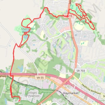
Prince William County Mountain Biking
Loop MTB around Haymarket via Leopold's Preserve, Silver Lake Regional Park, Catharpin Creek and James S. Long Park. #MTB #Loop #Nature #Forest #Park #Lake
- Distance: 27.4 Km
- Elevation gain: 180 m
- Maximum elevation: 141 m
- Elevation loss: 180 m
- Minimum elevation: 99 m
- Moving time: 2 h 18 s
- Moving speed: 13.6 Km/h
- Maximum speed: 32.3 Km/h
- Total time: 2 h 4 m
- Global speed: 13.2 Km/h
Interactive trail map
Make a donation
Gear up for your next adventure:
As an Amazon Associate, this site earns from qualifying purchases at no extra cost to you.
Trail profile
- Distance: 27.4 Km
- Elevation gain: 180 m
- Maximum elevation: 141 m
- Elevation loss: 180 m
- Minimum elevation: 99 m
- Moving time: 2 h 18 s
- Moving speed: 13.6 Km/h
- Maximum speed: 32.3 Km/h
- Total time: 2 h 4 m
- Global speed: 13.2 Km/h
Make a donation
Gear up for your next adventure:
As an Amazon Associate, this site earns from qualifying purchases at no extra cost to you.
About this trail
Name: Prince William County Mountain Biking trail, distance, elevation, map, profile, GPS track
Coordinates: 38.80799 -77.67550 38.85662 -77.62138
Make a donation
Gear up for your next adventure:
As an Amazon Associate, this site earns from qualifying purchases at no extra cost to you.
Other hiking, mountain biking, running and outdoor activity trails
Click on a trail to view its statistics, map and profile.
Prince William County Mountain Biking
United States > Virginia > Prince William County
New trail reroute at long park
Distance: 5.8 Km • Elevation gain: 54 m • Maximum elevation: 121 m