Make a donation
Gear up for your next adventure:
As an Amazon Associate, this site earns from qualifying purchases at no extra cost to you.
Brisbane Trail Run
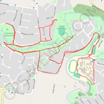
- Distance: 8.9 Km
- Elevation gain: 94 m
- Maximum elevation: 41 m
- Elevation loss: 95 m
- Minimum elevation: 13 m
- Moving time: 1 h 1 m
- Moving speed: 8.7 Km/h
- Maximum speed: 14.0 Km/h
- Total time: 1 h 1 m
- Global speed: 8.7 Km/h
Interactive trail map
Make a donation
Gear up for your next adventure:
As an Amazon Associate, this site earns from qualifying purchases at no extra cost to you.
Trail profile
- Distance: 8.9 Km
- Elevation gain: 94 m
- Maximum elevation: 41 m
- Elevation loss: 95 m
- Minimum elevation: 13 m
- Moving time: 1 h 1 m
- Moving speed: 8.7 Km/h
- Maximum speed: 14.0 Km/h
- Total time: 1 h 1 m
- Global speed: 8.7 Km/h
Make a donation
Gear up for your next adventure:
As an Amazon Associate, this site earns from qualifying purchases at no extra cost to you.
About this trail
Name: Brisbane Trail Run trail, distance, elevation, map, profile, GPS track
Start: 62, Dumbarton Drive, Kenmore, Greater Brisbane, Queensland, 4069, Australia (-27.50973 152.92996)
End: 60, Dumbarton Drive, Kenmore, Greater Brisbane, Queensland, 4069, Australia (-27.51003 152.93006)
Coordinates: -27.51014 152.91813 -27.50260 152.93070
Topography: Queensland topographic map, elevation, terrain
Make a donation
Gear up for your next adventure:
As an Amazon Associate, this site earns from qualifying purchases at no extra cost to you.
Other hiking, mountain biking, running and outdoor activity trails
Click on a trail to view its statistics, map and profile.