Thank you for supporting this site ❤️
Make a donation
Make a donation
Gear up for your next adventure:
As an Amazon Associate, this site earns from qualifying purchases at no extra cost to you.
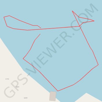
Waypoints_19-JUL-23
- Distance: 0.5 Km
- Elevation gain: 2 m
- Maximum elevation: 78 m
- Elevation loss: 2 m
- Minimum elevation: 75 m
- Moving time: 52 m 41 s
- Moving speed: 0.6 Km/h
- Maximum speed: 0.3 Km/h
- Total time: 8 h 9 m
- Global speed: 0.1 Km/h
Interactive trail map
Thank you for supporting this site ❤️
Make a donation
Make a donation
Gear up for your next adventure:
As an Amazon Associate, this site earns from qualifying purchases at no extra cost to you.
Trail profile
- Distance: 0.5 Km
- Elevation gain: 2 m
- Maximum elevation: 78 m
- Elevation loss: 2 m
- Minimum elevation: 75 m
- Moving time: 52 m 41 s
- Moving speed: 0.6 Km/h
- Maximum speed: 0.3 Km/h
- Total time: 8 h 9 m
- Global speed: 0.1 Km/h
Thank you for supporting this site ❤️
Make a donation
Make a donation
Gear up for your next adventure:
As an Amazon Associate, this site earns from qualifying purchases at no extra cost to you.
About this trail
Name: Waypoints_19-JUL-23 trail, distance, elevation, map, profile, GPS track
Coordinates: 44.16983 -76.24591 44.17087 -76.24420
Thank you for supporting this site ❤️
Make a donation
Make a donation
Gear up for your next adventure:
As an Amazon Associate, this site earns from qualifying purchases at no extra cost to you.
Other hiking, mountain biking, running and outdoor activity trails
Click on a trail to view its statistics, map and profile.