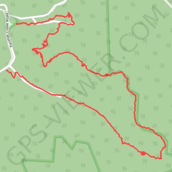
Loop Trail - Panther Wildlife Management Area
Hiking, trail
- Distance: 6.1 Km
- Elevation gain: 334 m
- Maximum elevation: 588 m
- Elevation loss: 332 m
- Minimum elevation: 352 m
- Moving time: 13 m 37 s
- Moving speed: 27.0 Km/h
- Maximum speed: 45.6 Km/h
- Total time: 13 m 37 s
- Global speed: 27.0 Km/h
Interactive trail map
Trail profile
- Distance: 6.1 Km
- Elevation gain: 334 m
- Maximum elevation: 588 m
- Elevation loss: 332 m
- Minimum elevation: 352 m
- Moving time: 13 m 37 s
- Moving speed: 27.0 Km/h
- Maximum speed: 45.6 Km/h
- Total time: 13 m 37 s
- Global speed: 27.0 Km/h
About this trail
Name: Loop Trail - Panther Wildlife Management Area trail, distance, elevation, map, profile, GPS track
Start: Buzzards Roost Overlook Trail, McDowell County, West Virginia, United States (37.42812 -81.86012)
End: Panther Creek Road, McDowell County, West Virginia, 24872, United States (37.42476 -81.86113)
Coordinates: 37.41834 -81.86113 37.42890 -81.84661
Other hiking, mountain biking, running and outdoor activity trails
Click on a trail to view its statistics, map and profile.
Loop Trail - Panther State Forest
United States > West Virginia > McDowell County
Hiking, trail
Distance: 6.1 Km • Elevation gain: 331 m • Maximum elevation: 588 m