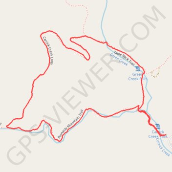
Carrick Creek Loop Trail in Table Rock State Park
The Carrick Creek Loop Trail is a delightful hike that immerses visitors in the beauty of South Carolina's upcountry. Along the route, you can enjoy the serene sounds of bubbling streams and discover several charming waterfalls nestled within a lush forest setting, creating a peaceful escape from urban life. This moderate loop is well-maintained and suitable for a range of hiking abilities, making it a perfect choice for families and nature lovers alike. #Hiking #Loop #Waterfall #River #Forest #Nature
- Distance: 3.1 Km
- Elevation gain: 122 m
- Maximum elevation: 473 m
- Elevation loss: 122 m
- Minimum elevation: 358 m
- Moving time: 56 m 44 s
- Moving speed: 3.3 Km/h
- Maximum speed: 5.8 Km/h
- Total time: 59 m 52 s
- Global speed: 3.1 Km/h
Interactive trail map
Trail profile
- Distance: 3.1 Km
- Elevation gain: 122 m
- Maximum elevation: 473 m
- Elevation loss: 122 m
- Minimum elevation: 358 m
- Moving time: 56 m 44 s
- Moving speed: 3.3 Km/h
- Maximum speed: 5.8 Km/h
- Total time: 59 m 52 s
- Global speed: 3.1 Km/h
About this trail
Name: Carrick Creek Loop Trail in Table Rock State Park trail, distance, elevation, map, profile, GPS track
Start: Pinnacle Mountain Trail, Pickens County, South Carolina, United States (35.03216 -82.70060)
Coordinates: 35.03191 -82.70951 35.03701 -82.70049
Other hiking, mountain biking, running and outdoor activity trails
Click on a trail to view its statistics, map and profile.
Table Rock Trail from Pinnacle Lake in Table Rock State Park
United States > South Carolina > Pickens County
The Table Rock Trail offers a visually rewarding experience with panoramic views of the surrounding mountains and the Table Rock Reservoir. As you ascend, you'll pass through lush, preserved forest landscapes and cross over multiple creeks, where small waterfalls add to the scenic charm of the hike. At the…
Distance: 11.3 Km • Elevation gain: 722 m • Maximum elevation: 944 m