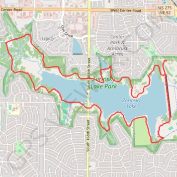
Zorinsky Lake Loop Trail in Omaha
The Zorinsky Lake Loop Trail offers a peaceful experience for hikers and cyclists, with much of the route running along the water's edge. You’ll encounter scenic views of the lake and occasional shaded stretches through wooded areas, particularly near Boxelder Creek. The well-maintained path provides a balance of open lake vistas and natural landscapes, making it a pleasant option for outdoor enthusiasts seeking both tranquility and varied terrain. #Hiking #Loop #Lake #Forest #Nature
- Distance: 11.6 Km
- Elevation gain: 100 m
- Maximum elevation: 351 m
- Elevation loss: 100 m
- Minimum elevation: 337 m
- Moving time: 1 h 12 s
- Moving speed: 11.5 Km/h
- Maximum speed: 26.6 Km/h
- Total time: 1 h 19 m
- Global speed: 8.8 Km/h
Interactive trail map
Trail profile
- Distance: 11.6 Km
- Elevation gain: 100 m
- Maximum elevation: 351 m
- Elevation loss: 100 m
- Minimum elevation: 337 m
- Moving time: 1 h 12 s
- Moving speed: 11.5 Km/h
- Maximum speed: 26.6 Km/h
- Total time: 1 h 19 m
- Global speed: 8.8 Km/h
About this trail
Name: Zorinsky Lake Loop Trail in Omaha trail, distance, elevation, map, profile, GPS track
Coordinates: 41.21314 -96.19423 41.23020 -96.15997