Alkali Flat Trail in White Sands National Park
The Alkali Flat Trail is a captivating experience, immersing you in a surreal landscape of shimmering white dunes and undulating terrain. As you traverse this five-mile path, you'll be greeted by stunning views of the San Andres Mountains in the distance and the intriguing dry lake bed that the dunes cover. The trail's markers keep you on track as you navigate the soft sands, making it an adventure that blends the beauty of nature with the thrill of exploration. #Hiking #Loop #Desert #Nature
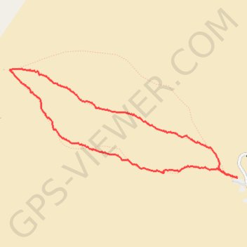
- Distance: 7.4 Km
- Elevation gain: 34 m
- Maximum elevation: 1,214 m
- Elevation loss: 34 m
- Minimum elevation: 1,199 m
- Moving time: 1 h 59 m
- Moving speed: 3.7 Km/h
- Maximum speed: 9.0 Km/h
- Total time: 2 h 41 m
- Global speed: 2.7 Km/h
Interactive trail map
Trail profile
- Distance: 7.4 Km
- Elevation gain: 34 m
- Maximum elevation: 1,214 m
- Elevation loss: 34 m
- Minimum elevation: 1,199 m
- Moving time: 1 h 59 m
- Moving speed: 3.7 Km/h
- Maximum speed: 9.0 Km/h
- Total time: 2 h 41 m
- Global speed: 2.7 Km/h
About this trail
Name: Alkali Flat Trail in White Sands National Park trail, distance, elevation, map, profile, GPS track
Start: Alkali Flat, Alkali Flat Trail, Otero County, New Mexico, United States (32.82070 -106.27254)
End: Alkali Flat, Alkali Flat Trail, Otero County, New Mexico, United States (32.82074 -106.27245)
Coordinates: 32.82070 -106.30414 32.83343 -106.27245