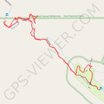
Red Reef and campground
- Distance: 3.7 Km
- Elevation gain: 172 m
- Maximum elevation: 1,045 m
- Elevation loss: 172 m
- Minimum elevation: 975 m
- Moving time: 1 h 8 m
- Moving speed: 3.3 Km/h
- Maximum speed: 13.4 Km/h
- Total time: 1 h 36 m
- Global speed: 2.3 Km/h
Interactive trail map
Trail profile
- Distance: 3.7 Km
- Elevation gain: 172 m
- Maximum elevation: 1,045 m
- Elevation loss: 172 m
- Minimum elevation: 975 m
- Moving time: 1 h 8 m
- Moving speed: 3.3 Km/h
- Maximum speed: 13.4 Km/h
- Total time: 1 h 36 m
- Global speed: 2.3 Km/h
About this trail
Name: Red Reef and campground trail, distance, elevation, map, profile, GPS track
Start: Anasazi, Washington County, Utah, United States (37.22327 -113.40401)
End: Anasazi, Washington County, Utah, United States (37.22330 -113.40386)
Coordinates: 37.22325 -113.41368 37.22943 -113.40386