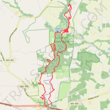
The Tuckahoe 25k
- Distance: 23.6 Km
- Elevation gain: 156 m
- Maximum elevation: 18 m
- Elevation loss: 157 m
- Minimum elevation: 3 m
- Moving time: 2 h 16 m
- Moving speed: 10.4 Km/h
- Maximum speed: 17.1 Km/h
- Total time: 2 h 16 m
- Global speed: 10.4 Km/h
Interactive trail map
Trail profile
- Distance: 23.6 Km
- Elevation gain: 156 m
- Maximum elevation: 18 m
- Elevation loss: 157 m
- Minimum elevation: 3 m
- Moving time: 2 h 16 m
- Moving speed: 10.4 Km/h
- Maximum speed: 17.1 Km/h
- Total time: 2 h 16 m
- Global speed: 10.4 Km/h
About this trail
Name: The Tuckahoe 25k trail, distance, elevation, map, profile, GPS track
Start: Caroline County, Maryland, 21641, United States (38.97558 -75.93334)
End: Caroline County, Maryland, 21641, United States (38.97571 -75.93353)
Coordinates: 38.92358 -75.95706 38.98362 -75.93209