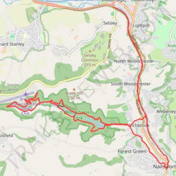
Woodchester Stroud Walking
- Distance: 22.7 Km
- Elevation gain: 491 m
- Maximum elevation: 211 m
- Elevation loss: 484 m
- Minimum elevation: 43 m
- Moving time: 4 h 19 m
- Moving speed: 5.3 Km/h
- Maximum speed: 9.9 Km/h
- Total time: 5 h 2 m
- Global speed: 4.5 Km/h
Interactive trail map
Trail profile
- Distance: 22.7 Km
- Elevation gain: 491 m
- Maximum elevation: 211 m
- Elevation loss: 484 m
- Minimum elevation: 43 m
- Moving time: 4 h 19 m
- Moving speed: 5.3 Km/h
- Maximum speed: 9.9 Km/h
- Total time: 5 h 2 m
- Global speed: 4.5 Km/h
About this trail
Name: Woodchester Stroud Walking trail, distance, elevation, map, profile, GPS track
Coordinates: 51.69441 -2.28777 51.73829 -2.21729
Other hiking, mountain biking, running and outdoor activity trails
Click on a trail to view its statistics, map and profile.
Five Valleys Loop Walk
United Kingdom > England > Gloucestershire > Stroud > Randwick
Distance: 34.2 Km • Elevation gain: 907 m • Maximum elevation: 253 m
Toadsmoor Valley
United Kingdom > England > Gloucestershire > Nailsworth > Box
Distance: 31.4 Km • Elevation gain: 839 m • Maximum elevation: 236 m
Loop walk from Nailsworth to Kingscote
United Kingdom > England > Gloucestershire > Nailsworth > Box
Distance: 12.2 Km • Elevation gain: 295 m • Maximum elevation: 213 m
Nailsworth - Brimscombe
United Kingdom > England > Gloucestershire > Nailsworth > Box
Distance: 10.3 Km • Elevation gain: 322 m • Maximum elevation: 205 m
Nailsworth to Cherington loop
United Kingdom > England > Gloucestershire > Nailsworth > Box
Distance: 18.2 Km • Elevation gain: 403 m • Maximum elevation: 191 m
Minchinhampton loop
United Kingdom > England > Gloucestershire > Nailsworth > Box
Distance: 21.1 Km • Elevation gain: 414 m • Maximum elevation: 205 m
NW to Stroud
United Kingdom > England > Gloucestershire > Nailsworth > Inchbrook
Stroud Walking
Distance: 19.2 Km • Elevation gain: 451 m • Maximum elevation: 200 m
Stroud-Haresfield
United Kingdom > England > Gloucestershire > Stonehouse
Distance: 26.4 Km • Elevation gain: 430 m • Maximum elevation: 246 m
Gatcombe Park
United Kingdom > England > Gloucestershire > Nailsworth > Box
Distance: 21.6 Km • Elevation gain: 452 m • Maximum elevation: 194 m
Dean2023-311
United Kingdom > England > Oxfordshire > Oxford
Distance: 310.3 Km • Elevation gain: 3,366 m • Maximum elevation: 290 m
Kingscote Glos
United Kingdom > England > Gloucestershire > Nailsworth > Box
Distance: 18.1 Km • Elevation gain: 357 m • Maximum elevation: 224 m
Stroud direct
United Kingdom > England > Gloucestershire > Nailsworth > Box
Distance: 16.2 Km • Elevation gain: 301 m • Maximum elevation: 205 m
Five Valleys
United Kingdom > England > Gloucestershire > Stonehouse > Leonard Stanley
Distance: 38.1 Km • Elevation gain: 882 m • Maximum elevation: 253 m
Avening
United Kingdom > England > Gloucestershire > Nailsworth > Box
Distance: 9.8 Km • Elevation gain: 258 m • Maximum elevation: 193 m