Thank you for supporting this site ❤️
Make a donation
Make a donation
Gear up for your next adventure:
As an Amazon Associate, this site earns from qualifying purchases at no extra cost to you.
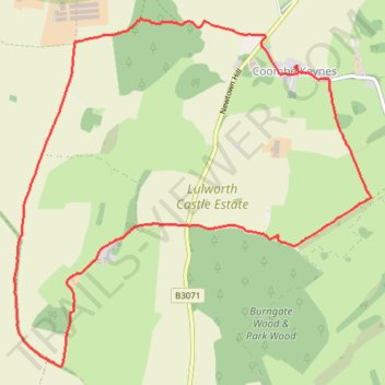
Coombe Wood, Belhuish, Coombe Keynes
- Distance: 8.8 Km
- Elevation gain: 163 m
- Maximum elevation: 147 m
- Elevation loss: 162 m
- Minimum elevation: 45 m
- Moving time: 1 h 37 m
- Moving speed: 5.4 Km/h
- Maximum speed: 7.5 Km/h
- Total time: 1 h 40 m
- Global speed: 5.3 Km/h
Interactive trail map
Thank you for supporting this site ❤️
Make a donation
Make a donation
Gear up for your next adventure:
As an Amazon Associate, this site earns from qualifying purchases at no extra cost to you.
Trail profile
- Distance: 8.8 Km
- Elevation gain: 163 m
- Maximum elevation: 147 m
- Elevation loss: 162 m
- Minimum elevation: 45 m
- Moving time: 1 h 37 m
- Moving speed: 5.4 Km/h
- Maximum speed: 7.5 Km/h
- Total time: 1 h 40 m
- Global speed: 5.3 Km/h
Thank you for supporting this site ❤️
Make a donation
Make a donation
Gear up for your next adventure:
As an Amazon Associate, this site earns from qualifying purchases at no extra cost to you.
About this trail
Name: Coombe Wood, Belhuish, Coombe Keynes trail, distance, elevation, map, profile, GPS track
Coordinates: 50.63914 -2.25158 50.66111 -2.21608
Thank you for supporting this site ❤️
Make a donation
Make a donation
Gear up for your next adventure:
As an Amazon Associate, this site earns from qualifying purchases at no extra cost to you.