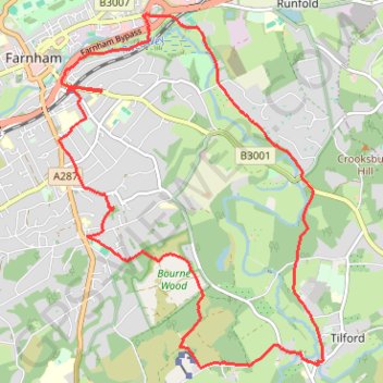
Farnham to Tilford
- Distance: 15.6 Km
- Elevation gain: 186 m
- Maximum elevation: 111 m
- Elevation loss: 187 m
- Minimum elevation: 50 m
- Moving time: 3 h 15 m
- Moving speed: 4.8 Km/h
- Maximum speed: 11.4 Km/h
- Total time: 4 h 13 m
- Global speed: 3.7 Km/h
Interactive trail map
Trail profile
- Distance: 15.6 Km
- Elevation gain: 186 m
- Maximum elevation: 111 m
- Elevation loss: 187 m
- Minimum elevation: 50 m
- Moving time: 3 h 15 m
- Moving speed: 4.8 Km/h
- Maximum speed: 11.4 Km/h
- Total time: 4 h 13 m
- Global speed: 3.7 Km/h
About this trail
Name: Farnham to Tilford trail, distance, elevation, map, profile, GPS track
Coordinates: 51.18300 -0.79428 51.21966 -0.75052
Other hiking, mountain biking, running and outdoor activity trails
Click on a trail to view its statistics, map and profile.
Brighton Hill - South Downs National Park
United Kingdom > England > Hampshire > Basingstoke and Deane > Basingstoke
MTB loop from Brighton Hill to South Downs National Park via Upton Grey, Long Sutton, Farnham, Tilford, Holt Pound, Lodge Inclosure, Bentley, Lower Froyle and South Warnborough. #MTB #Loop #Nature #Countryside #Forest
Distance: 68.2 Km • Elevation gain: 914 m • Maximum elevation: 183 m
Millbridge, Pierrepont Farm, Farnham Brewery, Farnham
United Kingdom > England > Surrey > Waverley > Frensham > Millbridge
Distance: 12.5 Km • Elevation gain: 168 m • Maximum elevation: 111 m
Tilford to Farnham via Bourne Wood
United Kingdom > England > Surrey > Waverley > Tilford
Distance: 9.9 Km • Elevation gain: 136 m • Maximum elevation: 109 m