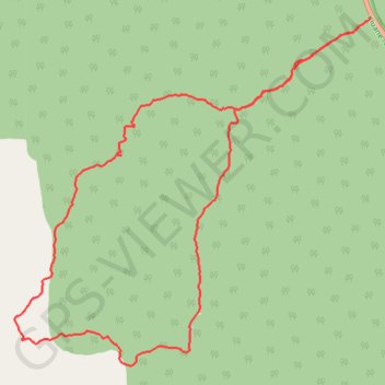
Auriol Loop Trail in Kluane Park Yukon Canada
- Distance: 15.3 Km
- Elevation gain: 410 m
- Maximum elevation: 1,170 m
- Elevation loss: 411 m
- Minimum elevation: 784 m
- Moving time: 3 h 51 m
- Moving speed: 4.0 Km/h
- Maximum speed: 13.6 Km/h
- Total time: 4 h 21 m
- Global speed: 3.5 Km/h
Interactive trail map
Trail profile
- Distance: 15.3 Km
- Elevation gain: 410 m
- Maximum elevation: 1,170 m
- Elevation loss: 411 m
- Minimum elevation: 784 m
- Moving time: 3 h 51 m
- Moving speed: 4.0 Km/h
- Maximum speed: 13.6 Km/h
- Total time: 4 h 21 m
- Global speed: 3.5 Km/h
About this trail
Name: Auriol Loop Trail in Kluane Park Yukon Canada trail, distance, elevation, map, profile, GPS track
Start: Auriol Trail, Yukon, Y0B 1L0, Canada (60.71740 -137.42470)
End: Auriol Trail, Yukon, Y0B 1L0, Canada (60.71749 -137.42468)
Coordinates: 60.68039 -137.50243 60.71749 -137.42468