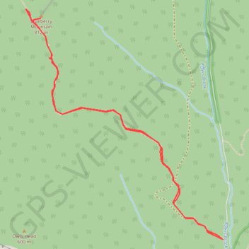
Blueberry Mountain
Hike to Blueberry Mountain via Blueberry Mountain Trail in the White Mountain National Forest. #Hiking #Mountain #Forest #Nature
- Distance: 5.6 Km
- Elevation gain: 321 m
- Maximum elevation: 802 m
- Elevation loss: 320 m
- Minimum elevation: 480 m
- Moving time: 1 h 19 m
- Moving speed: 4.2 Km/h
- Maximum speed: 6.4 Km/h
- Total time: 1 h 19 m
- Global speed: 4.2 Km/h
Interactive trail map
Trail profile
- Distance: 5.6 Km
- Elevation gain: 321 m
- Maximum elevation: 802 m
- Elevation loss: 320 m
- Minimum elevation: 480 m
- Moving time: 1 h 19 m
- Moving speed: 4.2 Km/h
- Maximum speed: 6.4 Km/h
- Total time: 1 h 19 m
- Global speed: 4.2 Km/h
About this trail
Name: Blueberry Mountain trail, distance, elevation, map, profile, GPS track
Coordinates: 44.00485 -71.90638 44.01983 -71.88859
Other hiking, mountain biking, running and outdoor activity trails
Click on a trail to view its statistics, map and profile.