Teneriffe Falls Trail in Mount Si Natural Resources Conservation Area
The Teneriffe Falls Trail in Washington's Mount Si Natural Resources Conservation Area offers hikers a journey through lush forests, crossing several streams via charming bridges. As you ascend, the trail provides glimpses of the surrounding valleys and mountains, with the possibility of spotting mountain goats on the open cliffs. The highlight is the picturesque Teneriffe Falls, best visited in spring when the waterfall flows at its fullest. #Hiking #Mountain #Forest #Nature #Waterfall
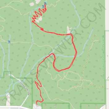
- Distance: 9.1 Km
- Elevation gain: 513 m
- Maximum elevation: 757 m
- Elevation loss: 513 m
- Minimum elevation: 248 m
- Moving time: 2 h 18 m
- Moving speed: 3.9 Km/h
- Maximum speed: 7.9 Km/h
- Total time: 2 h 23 m
- Global speed: 3.8 Km/h
Interactive trail map
Trail profile
- Distance: 9.1 Km
- Elevation gain: 513 m
- Maximum elevation: 757 m
- Elevation loss: 513 m
- Minimum elevation: 248 m
- Moving time: 2 h 18 m
- Moving speed: 3.9 Km/h
- Maximum speed: 7.9 Km/h
- Total time: 2 h 23 m
- Global speed: 3.8 Km/h
About this trail
Name: Teneriffe Falls Trail in Mount Si Natural Resources Conservation Area trail, distance, elevation, map, profile, GPS track
Start: Mount Teneriffe Trail, King County, Washington, United States (47.48703 -121.71002)
End: Mount Teneriffe Trail, King County, Washington, United States (47.48698 -121.70998)
Coordinates: 47.48698 -121.71108 47.50181 -121.70134
Other hiking, mountain biking, running and outdoor activity trails
Click on a trail to view its statistics, map and profile.
Teneriffe Falls Trail
United States > Washington > King County
Starting at the Mount Teneriffe trailhead, this hike follows the forested Mount Teneriffe Trail through the Mount Si Natural Resources Conservation Area, with occasional openings toward the Snoqualmie Valley and nearby peaks. The route then turns onto the Teneriffe Falls Trail, climbing more steeply through…
Distance: 9.5 Km • Elevation gain: 555 m • Maximum elevation: 760 m
Mount Teneriffe via Teneriffe Falls Trail and Kamikaze Trail
United States > Washington > King County
The hike to Mount Teneriffe offers a combination of natural beauty and physical challenge in Mount Si Natural Resources Conservation Area. The trail begins with a serene forested path leading to the striking Teneriffe Falls, which are especially impressive during the spring. Continuing upwards, the…
Distance: 12.1 Km • Elevation gain: 1,176 m • Maximum elevation: 1,396 m
Mount Si Trail and Mount Teneriffe Trail Loop
United States > Washington > King County
The loop hike via Mount Si and Mount Teneriffe Trails provides an exceptional experience in the Mount Si Natural Resources Conservation Area. The route offers a mix of dense, lush forests and sweeping vistas, including views of Mount Rainier, Rattlesnake Ridge, and the surrounding Cascades. Hikers will…
Distance: 14.0 Km • Elevation gain: 1,014 m • Maximum elevation: 1,205 m
Northern part of the Pacific Crest Trail (PCT)
United States > Oregon > Klamath County
Hike on the Pacific Crest National Scenic Trail from Crater Lake to Canada Border through Oregon and Washington along the Sierra Nevada and Cascade mountain ranges. #Hiking #Mountain #SierraNevada #Cascade #Nature #Forest #Park #PCT
Distance: 1,198.3 Km • Elevation gain: 44,308 m • Maximum elevation: 2,307 m
Track (8/12/23, 7:47:57AM)
United States > Washington > King County
Distance: 57.9 Km • Elevation gain: 3,713 m • Maximum elevation: 1,404 m