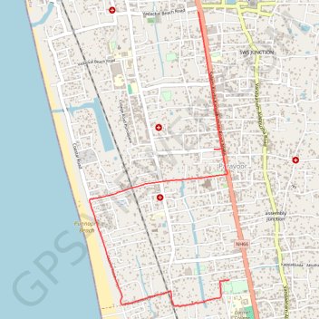
20240210100212
- Distance: 5.7 Km
- Elevation gain: 11 m
- Maximum elevation: 11 m
- Elevation loss: 9 m
- Minimum elevation: 3 m
- Moving time: 18 m 11 s
- Moving speed: 18.7 Km/h
- Maximum speed: 38.3 Km/h
- Total time: 20 m 19 s
- Global speed: 16.8 Km/h
Interactive trail map
Trail profile
- Distance: 5.7 Km
- Elevation gain: 11 m
- Maximum elevation: 11 m
- Elevation loss: 9 m
- Minimum elevation: 3 m
- Moving time: 18 m 11 s
- Moving speed: 18.7 Km/h
- Maximum speed: 38.3 Km/h
- Total time: 20 m 19 s
- Global speed: 16.8 Km/h
About this trail
Name: 20240210100212 trail, distance, elevation, map, profile, GPS track
Start: Mathapithabhavan, Paravoor, Ambalappuzha, Alappuzha, Kerala, 688004, India (9.44211 76.34175)
End: NH66, Alappuzha, Ambalappuzha, Alappuzha, Kerala, 688001, India (9.46579 76.33898)
Coordinates: 9.43972 76.32921 9.46579 76.34175