Make a donation
Gear up for your next adventure:
As an Amazon Associate, this site earns from qualifying purchases at no extra cost to you.
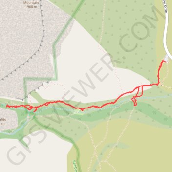
Pine Creek Trail
Hike on the Pine Creek Trail and the Fire Ecology Loop Trail in the Red Rock Canyon National Conservation Area and the Rainbow Mountain Wilderness. #Hiking #Mountain #Nature #Forest
- Distance: 5.6 Km
- Elevation gain: 145 m
- Maximum elevation: 1,319 m
- Elevation loss: 149 m
- Minimum elevation: 1,203 m
- Moving time: 1 h 45 m
- Moving speed: 3.2 Km/h
- Maximum speed: 10.6 Km/h
- Total time: 2 h 38 m
- Global speed: 2.1 Km/h
Interactive trail map
Make a donation
Gear up for your next adventure:
As an Amazon Associate, this site earns from qualifying purchases at no extra cost to you.
Trail profile
- Distance: 5.6 Km
- Elevation gain: 145 m
- Maximum elevation: 1,319 m
- Elevation loss: 149 m
- Minimum elevation: 1,203 m
- Moving time: 1 h 45 m
- Moving speed: 3.2 Km/h
- Maximum speed: 10.6 Km/h
- Total time: 2 h 38 m
- Global speed: 2.1 Km/h
Make a donation
Gear up for your next adventure:
As an Amazon Associate, this site earns from qualifying purchases at no extra cost to you.
About this trail
Name: Pine Creek Trail trail, distance, elevation, map, profile, GPS track
Start: Pine Creek Trail, Clark County, Nevada, United States (36.12865 -115.47346)
End: Pine Creek Trail, Clark County, Nevada, United States (36.12866 -115.47383)
Coordinates: 36.12354 -115.49367 36.12881 -115.47346
Make a donation
Gear up for your next adventure:
As an Amazon Associate, this site earns from qualifying purchases at no extra cost to you.