Thank you for supporting this site ❤️
Make a donation
Make a donation
Gear up for your next adventure:
As an Amazon Associate, this site earns from qualifying purchases at no extra cost to you.
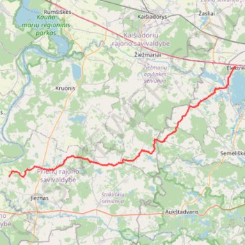
Elektrėnai - Sodyba
- Distance: 52.7 Km
- Elevation gain: 428 m
- Maximum elevation: 207 m
- Elevation loss: 434 m
- Minimum elevation: 56 m
- Moving time: 3 h 18 m
- Moving speed: 15.9 Km/h
- Maximum speed: 36.3 Km/h
- Total time: 3 h 18 m
- Global speed: 15.9 Km/h
Interactive trail map
Thank you for supporting this site ❤️
Make a donation
Make a donation
Gear up for your next adventure:
As an Amazon Associate, this site earns from qualifying purchases at no extra cost to you.
Trail profile
- Distance: 52.7 Km
- Elevation gain: 428 m
- Maximum elevation: 207 m
- Elevation loss: 434 m
- Minimum elevation: 56 m
- Moving time: 3 h 18 m
- Moving speed: 15.9 Km/h
- Maximum speed: 36.3 Km/h
- Total time: 3 h 18 m
- Global speed: 15.9 Km/h
Thank you for supporting this site ❤️
Make a donation
Make a donation
Gear up for your next adventure:
As an Amazon Associate, this site earns from qualifying purchases at no extra cost to you.
About this trail
Name: Elektrėnai - Sodyba trail, distance, elevation, map, profile, GPS track
Coordinates: 54.62929 24.09985 54.78702 24.66238
Thank you for supporting this site ❤️
Make a donation
Make a donation
Gear up for your next adventure:
As an Amazon Associate, this site earns from qualifying purchases at no extra cost to you.