Table Rock Viewpoint and Table Rock Quarry Loop Trail
The Table Rock Viewpoint and Quarry Loop Trail is a well-loved hike offering panoramic views of the city, the Boise River, and the surrounding foothills. Starting near the Old Idaho Penitentiary, this moderately challenging trail winds through sagebrush and grasslands, leading to a flat mesa with a prominent cross overlooking the valley. While parts of the trail can be busy and show signs of wear, the expansive views and the connection to Boise's landscape make it a rewarding trek for outdoor enthusiasts and photographers alike. #Hiking #Loop #Nature
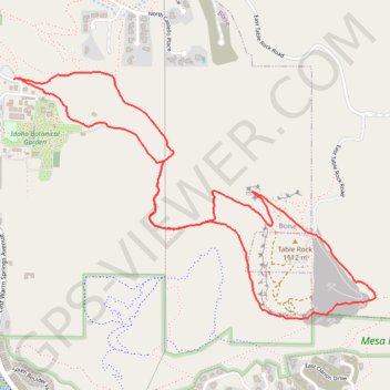
- Distance: 6.2 Km
- Elevation gain: 293 m
- Maximum elevation: 1,113 m
- Elevation loss: 293 m
- Minimum elevation: 845 m
- Moving time: 1 h 49 m
- Moving speed: 3.4 Km/h
- Maximum speed: 5.4 Km/h
- Total time: 2 h 14 m
- Global speed: 2.8 Km/h
Interactive trail map
Trail profile
- Distance: 6.2 Km
- Elevation gain: 293 m
- Maximum elevation: 1,113 m
- Elevation loss: 293 m
- Minimum elevation: 845 m
- Moving time: 1 h 49 m
- Moving speed: 3.4 Km/h
- Maximum speed: 5.4 Km/h
- Total time: 2 h 14 m
- Global speed: 2.8 Km/h
About this trail
Name: Table Rock Viewpoint and Table Rock Quarry Loop Trail trail, distance, elevation, map, profile, GPS track
End: #15A Old Pen, East End, Boise, Ada County, Idaho, 83712, United States (43.60364 -116.16244)
Coordinates: 43.59288 -116.16251 43.60396 -116.14019