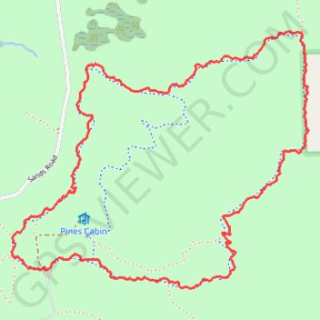
Bloomer Loop Trail - Ortonville State Recreation Area
- Distance: 4.8 Km
- Elevation gain: 60 m
- Maximum elevation: 352 m
- Elevation loss: 60 m
- Minimum elevation: 310 m
- Moving time: 53 m 35 s
- Moving speed: 5.4 Km/h
- Maximum speed: 22.7 Km/h
- Total time: 53 m 35 s
- Global speed: 5.4 Km/h
Interactive trail map
Trail profile
- Distance: 4.8 Km
- Elevation gain: 60 m
- Maximum elevation: 352 m
- Elevation loss: 60 m
- Minimum elevation: 310 m
- Moving time: 53 m 35 s
- Moving speed: 5.4 Km/h
- Maximum speed: 22.7 Km/h
- Total time: 53 m 35 s
- Global speed: 5.4 Km/h
About this trail
Name: Bloomer Loop Trail - Ortonville State Recreation Area trail, distance, elevation, map, profile, GPS track
Start: Mountain Bike Trail, Oakland County, Michigan, 48462, United States (42.86888 -83.43830)
End: Mountain Bike Trail, Oakland County, Michigan, 48462, United States (42.86886 -83.43838)
Coordinates: 42.86821 -83.44005 42.87763 -83.42523