Thank you for supporting this site ❤️
Make a donation
Make a donation
Gear up for your next adventure:
As an Amazon Associate, this site earns from qualifying purchases at no extra cost to you.
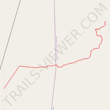
Hel se Pad Pass
- Distance: 16.7 Km
- Elevation gain: 580 m
- Maximum elevation: 804 m
- Elevation loss: 11 m
- Minimum elevation: 234 m
- Moving time: 41 m 59 s
- Moving speed: 23.8 Km/h
- Maximum speed: 43.3 Km/h
- Total time: 43 m 42 s
- Global speed: 22.9 Km/h
Interactive trail map
Thank you for supporting this site ❤️
Make a donation
Make a donation
Gear up for your next adventure:
As an Amazon Associate, this site earns from qualifying purchases at no extra cost to you.
Trail profile
- Distance: 16.7 Km
- Elevation gain: 580 m
- Maximum elevation: 804 m
- Elevation loss: 11 m
- Minimum elevation: 234 m
- Moving time: 41 m 59 s
- Moving speed: 23.8 Km/h
- Maximum speed: 43.3 Km/h
- Total time: 43 m 42 s
- Global speed: 22.9 Km/h
Thank you for supporting this site ❤️
Make a donation
Make a donation
Gear up for your next adventure:
As an Amazon Associate, this site earns from qualifying purchases at no extra cost to you.
About this trail
Name: Hel se Pad Pass trail, distance, elevation, map, profile, GPS track
Coordinates: -31.21338 18.89336 -31.15083 19.00458
Thank you for supporting this site ❤️
Make a donation
Make a donation
Gear up for your next adventure:
As an Amazon Associate, this site earns from qualifying purchases at no extra cost to you.