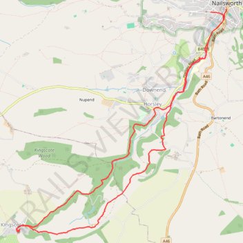
Nailsworth to Kingscote Loop
- Distance: 11.7 Km
- Elevation gain: 273 m
- Maximum elevation: 213 m
- Elevation loss: 273 m
- Minimum elevation: 65 m
- Moving time: 2 h 25 m
- Moving speed: 4.8 Km/h
- Maximum speed: 8.6 Km/h
- Total time: 2 h 44 m
- Global speed: 4.3 Km/h
Interactive trail map
Trail profile
About this trail
Name: Nailsworth to Kingscote Loop trail, distance, elevation, map, profile, GPS track
Coordinates: 51.66405 -2.26429 51.69440 -2.21850
Other hiking, mountain biking, running and outdoor activity trails
Click on a trail to view its statistics, map and profile.
Nailsworth to Cherington loop
United Kingdom > England > Gloucestershire > Nailsworth > Box
Distance: 18.2 Km • Elevation gain: 403 m • Maximum elevation: 191 m
Avening loop
United Kingdom > England > Gloucestershire > Nailsworth > Box
Distance: 17.8 Km • Elevation gain: 329 m • Maximum elevation: 186 m
Nailsworth - Brimscombe
United Kingdom > England > Gloucestershire > Nailsworth > Box
Distance: 10.3 Km • Elevation gain: 322 m • Maximum elevation: 205 m
Five Valleys Loop Walk
United Kingdom > England > Gloucestershire > Stroud > Randwick
Distance: 34.2 Km • Elevation gain: 907 m • Maximum elevation: 253 m
Loop walk from Nailsworth to Kingscote
United Kingdom > England > Gloucestershire > Nailsworth > Box
Distance: 12.2 Km • Elevation gain: 295 m • Maximum elevation: 213 m
Kingscote Glos
United Kingdom > England > Gloucestershire > Nailsworth > Downend
Loop hike between Nailsworth and Kingscote. #Hiking #Loop #Nature #Forest #Countryside
Distance: 11.2 Km • Elevation gain: 295 m • Maximum elevation: 215 m
Gatcombe Park
United Kingdom > England > Gloucestershire > Nailsworth > Box
Distance: 21.6 Km • Elevation gain: 452 m • Maximum elevation: 194 m
Kingscote Glos
United Kingdom > England > Gloucestershire > Nailsworth > Box
Distance: 18.1 Km • Elevation gain: 357 m • Maximum elevation: 224 m
NW to Stroud
United Kingdom > England > Gloucestershire > Nailsworth > Inchbrook
Stroud Walking
Distance: 19.2 Km • Elevation gain: 451 m • Maximum elevation: 200 m
Dean2023-311
United Kingdom > England > Oxfordshire > Oxford
Distance: 310.3 Km • Elevation gain: 3,366 m • Maximum elevation: 290 m