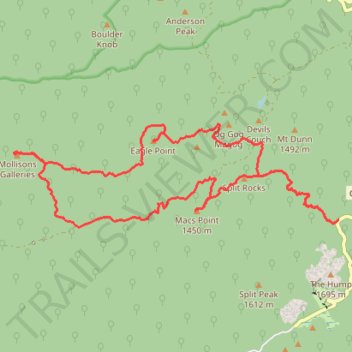
Macks Point Track, Mollisons Galleries and Eagle Point Loop
- Distance: 21.4 Km
- Elevation gain: 751 m
- Maximum elevation: 1,514 m
- Elevation loss: 751 m
- Minimum elevation: 1,130 m
- Moving time: 3 h 39 m
- Moving speed: 5.8 Km/h
- Maximum speed: 18.9 Km/h
- Total time: 4 h 25 m
- Global speed: 4.8 Km/h
Interactive trail map
Trail profile
- Distance: 21.4 Km
- Elevation gain: 751 m
- Maximum elevation: 1,514 m
- Elevation loss: 751 m
- Minimum elevation: 1,130 m
- Moving time: 3 h 39 m
- Moving speed: 5.8 Km/h
- Maximum speed: 18.9 Km/h
- Total time: 4 h 25 m
- Global speed: 4.8 Km/h
About this trail
Name: Macks Point Track, Mollisons Galleries and Eagle Point Loop trail, distance, elevation, map, profile, GPS track
Start: Mount Buffalo Road, Mount Buffalo, Alpine Shire, Victoria, Australia (-36.74983 146.78891)
End: Mount Buffalo Road, Mount Buffalo, Alpine Shire, Victoria, Australia (-36.74959 146.78912)
Coordinates: -36.75082 146.72389 -36.73430 146.78912
Topography: Victoria topographic map, elevation, terrain
Other hiking, mountain biking, running and outdoor activity trails
Click on a trail to view its statistics, map and profile.