Make a donation
Gear up for your next adventure:
As an Amazon Associate, this site earns from qualifying purchases at no extra cost to you.
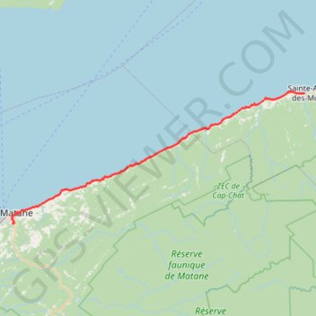
Matane - Sainte-Anne-des-Monts
Saint Lawrence River. #Bike #Matane #SainteAnneDesMonts #SaintLawrence
- Distance: 88.8 Km
- Elevation gain: 788 m
- Maximum elevation: 90 m
- Elevation loss: 802 m
- Minimum elevation: 0 m
Interactive trail map
Make a donation
Gear up for your next adventure:
As an Amazon Associate, this site earns from qualifying purchases at no extra cost to you.
Trail profile
- Distance: 88.8 Km
- Elevation gain: 788 m
- Maximum elevation: 90 m
- Elevation loss: 802 m
- Minimum elevation: 0 m
Make a donation
Gear up for your next adventure:
As an Amazon Associate, this site earns from qualifying purchases at no extra cost to you.
About this trail
Name: Matane - Sainte-Anne-des-Monts trail, distance, elevation, map, profile, GPS track
Coordinates: 48.82088 -67.54630 49.12713 -66.51072
Make a donation
Gear up for your next adventure:
As an Amazon Associate, this site earns from qualifying purchases at no extra cost to you.
Other hiking, mountain biking, running and outdoor activity trails
Click on a trail to view its statistics, map and profile.
Sainte-Anne-des-Monts - Madeleine
Canada > Quebec > La Haute-Gaspésie > Sainte-Anne-des-Monts
Saint Lawrence River. #Bike #SainteAnneDesMonts #Madeleine #SaintLawrence
Distance: 92.5 Km • Elevation gain: 866 m • Maximum elevation: 107 m
Rimouski - Matane
Canada > Quebec > Rimouski-Neigette > Rimouski > L'Anse-au-Sable
Saint Lawrence River. #Bike #Rimouski #Matane #SaintLawrence
Distance: 104.5 Km • Elevation gain: 485 m • Maximum elevation: 58 m