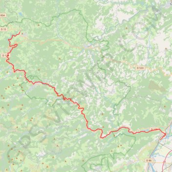
Dolce Via 1
This is track no: 1
- Distance: 72.1 Km
- Elevation gain: 1,785 m
- Maximum elevation: 1,052 m
- Elevation loss: 828 m
- Minimum elevation: 94 m
Interactive trail map
Trail profile
- Distance: 72.1 Km
- Elevation gain: 1,785 m
- Maximum elevation: 1,052 m
- Elevation loss: 828 m
- Minimum elevation: 94 m
About this trail
Name: Dolce Via 1 trail, distance, elevation, map, profile, GPS track
Coordinates: 44.80118 4.35082 45.01509 4.79808
Other hiking, mountain biking, running and outdoor activity trails
Click on a trail to view its statistics, map and profile.
Southern section — European Divide Trail
France > Auvergne-Rhône-Alpes > Drôme > Valence
Distance: 2,423.8 Km • Elevation gain: 42,375 m • Maximum elevation: 2,005 m
PT23DS2 Lörrach → Cadaqués
Germany > Baden-Württemberg > Landkreis Lörrach > Lörrach (Kernstadt)
Distance: 1,050.7 Km • Elevation gain: 13,130 m • Maximum elevation: 1,505 m
Chemin de Saint-Jacques-de-Compostelle
Switzerland > Geneva > Geneva
Distance: 1,117.8 Km • Elevation gain: 25,262 m • Maximum elevation: 1,430 m