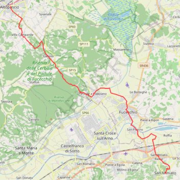
Tappa-29-da-altopascio-san-miniato
- Distance: 29.0 Km
- Elevation gain: 354 m
- Maximum elevation: 147 m
- Elevation loss: 228 m
- Minimum elevation: 12 m
Interactive trail map
Trail profile
- Distance: 29.0 Km
- Elevation gain: 354 m
- Maximum elevation: 147 m
- Elevation loss: 228 m
- Minimum elevation: 12 m
About this trail
Name: Tappa-29-da-altopascio-san-miniato trail, distance, elevation, map, profile, GPS track
Start: Piazza Giuseppe Garibaldi, Altopascio, Lucca, Tuscany, 55011, Italy (43.81512 10.67532)
End: Gargozzi, La Scala, San Miniato, Pisa, Tuscany, 56028, Italy (43.67935 10.85148)
Coordinates: 43.67933 10.67532 43.81512 10.85517
Other hiking, mountain biking, running and outdoor activity trails
Click on a trail to view its statistics, map and profile.
1 LUCENA - MONTPELLIER
Distance: 2,964.4 Km • Elevation gain: 29,500 m • Maximum elevation: 1,048 m
VFS - IT29 - SanMiniato - GambassiTerme.gpx (1)
Italy > Tuscany > Pisa > San Miniato > La Scala > Gargozzi
Distance: 24.0 Km • Elevation gain: 725 m • Maximum elevation: 317 m