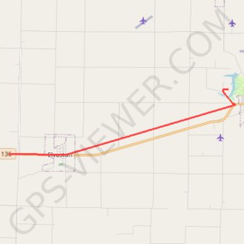
2023-10-21T17:27:28.973471
- Distance: 12.4 Km
- Elevation gain: 37 m
- Maximum elevation: 211 m
- Elevation loss: 32 m
- Minimum elevation: 198 m
- Moving time: 9 m 59 s
- Moving speed: 74.3 Km/h
- Maximum speed: 23.7 Km/h
- Total time: 9 m 59 s
- Global speed: 74.3 Km/h
Interactive trail map
Trail profile
- Distance: 12.4 Km
- Elevation gain: 37 m
- Maximum elevation: 211 m
- Elevation loss: 32 m
- Minimum elevation: 198 m
- Moving time: 9 m 59 s
- Moving speed: 74.3 Km/h
- Maximum speed: 23.7 Km/h
- Total time: 9 m 59 s
- Global speed: 74.3 Km/h
About this trail
Name: 2023-10-21T17:27:28.973471 trail, distance, elevation, map, profile, GPS track
Start: 1173, US Highway 136, Hamilton, Hancock County, Illinois, 62379, United States (40.39537 -91.27745)
End: Hancock County, Illinois, 62336, United States (40.42244 -91.15672)
Coordinates: 40.39493 -91.27745 40.42253 -91.15290