Green Lakes Trail in Deschutes National Forest
The Green Lakes Trail is a captivating hike weaving through lush forests along Fall Creek, with glimpses of cascading waterfalls and a backdrop of volcanic landscapes. As the trail ascends, hikers are treated to wildflower meadows and dramatic lava flows, leading to the tranquil Green Lakes basin nestled between South Sister and Broken Top peaks. This route offers a harmonious blend of serene alpine lakes and rugged wilderness, making it a cherished destination for nature enthusiasts. #Hiking #Mountain #Lake #Forest #Nature #Waterfall
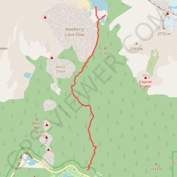
- Distance: 15.5 Km
- Elevation gain: 393 m
- Maximum elevation: 2,000 m
- Elevation loss: 393 m
- Minimum elevation: 1,657 m
Interactive trail map
Trail profile
- Distance: 15.5 Km
- Elevation gain: 393 m
- Maximum elevation: 2,000 m
- Elevation loss: 393 m
- Minimum elevation: 1,657 m
About this trail
Name: Green Lakes Trail in Deschutes National Forest trail, distance, elevation, map, profile, GPS track
Start: Green Lakes Trail #17, Deschutes County, Oregon, United States (44.03131 -121.73615)
End: Green Lakes Trail #17, Deschutes County, Oregon, United States (44.03133 -121.73611)
Coordinates: 44.03131 -121.74339 44.08514 -121.72781
Other hiking, mountain biking, running and outdoor activity trails
Click on a trail to view its statistics, map and profile.
Northern part of the Pacific Crest Trail (PCT)
United States > Oregon > Klamath County
Hike on the Pacific Crest National Scenic Trail from Crater Lake to Canada Border through Oregon and Washington along the Sierra Nevada and Cascade mountain ranges. #Hiking #Mountain #SierraNevada #Cascade #Nature #Forest #Park #PCT
Distance: 1,198.3 Km • Elevation gain: 44,308 m • Maximum elevation: 2,307 m