Import a GPX file

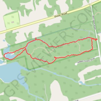
Scout Tract Regional Forest

#Hiking #Loop

  • Distance: 3.5 Km
  • Elevation gain: 38 m
  • Maximum elevation: 324 m
  • Elevation loss: 38 m
  • Minimum elevation: 286 m

Interactive trail map

Trail profile

  • Distance: 3.5 Km
  • Elevation gain: 38 m
  • Maximum elevation: 324 m
  • Elevation loss: 38 m
  • Minimum elevation: 286 m

About this trail

👉 Easily get elevation data in JSON, GeoTIFF and KML formats using Elevation API
Thank you for supporting this site ❤️
Make a donation

Gear up for your next adventure:

As an Amazon Associate, this site earns from qualifying purchases at no extra cost to you.

Other hiking, mountain biking, running and outdoor activity trails

Click on a trail to view its statistics, map and profile.

Québec - Montréal - Saint-Laurent River - Lake Ontario - Niagara Falls

Canada > Quebec > Urban agglomeration of Québec > Quebec

#Bike #Ontario

Distance: 1,078.4 Km • Elevation gain: 4,804 m • Maximum elevation: 209 m

Gear up for your next adventure:

🚁Camera Drones with GPS - Capture aerial views of the landscape to compare with topo maps
🖼️Scratch-off Australia Map - Track the regions and peaks you have explored geographically
🚴Cycling Backpacks - Backpacks for cyclists
🦟Insect Repellent - Protection against insects
🧴SPF 50+ Bulk Sunscreen - Maximum protection for long-term outdoor exposure

As an Amazon Associate, this site earns from qualifying purchases at no extra cost to you.