Make a donation
Gear up for your next adventure:
As an Amazon Associate, this site earns from qualifying purchases at no extra cost to you.
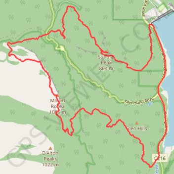
Bellfield > Sundial > Rosea
- Distance: 25.6 Km
- Elevation gain: 1,045 m
- Maximum elevation: 988 m
- Elevation loss: 1,045 m
- Minimum elevation: 280 m
- Moving time: 3 h 39 m
- Moving speed: 7.0 Km/h
- Maximum speed: 15.9 Km/h
- Total time: 4 h 7 m
- Global speed: 6.2 Km/h
Interactive trail map
Make a donation
Gear up for your next adventure:
As an Amazon Associate, this site earns from qualifying purchases at no extra cost to you.
Trail profile
- Distance: 25.6 Km
- Elevation gain: 1,045 m
- Maximum elevation: 988 m
- Elevation loss: 1,045 m
- Minimum elevation: 280 m
- Moving time: 3 h 39 m
- Moving speed: 7.0 Km/h
- Maximum speed: 15.9 Km/h
- Total time: 4 h 7 m
- Global speed: 6.2 Km/h
Make a donation
Gear up for your next adventure:
As an Amazon Associate, this site earns from qualifying purchases at no extra cost to you.
About this trail
Name: Bellfield > Sundial > Rosea trail, distance, elevation, map, profile, GPS track
Coordinates: -37.21731 142.48882 -37.17189 142.54509
Topography: Victoria topographic map, elevation, terrain
Make a donation
Gear up for your next adventure:
As an Amazon Associate, this site earns from qualifying purchases at no extra cost to you.
Other hiking, mountain biking, running and outdoor activity trails
Click on a trail to view its statistics, map and profile.
Halls Gap, The Pinnacle, Mount Rosea and Bellfield Lake loop
Australia > Victoria > Halls Gap
Distance: 30.4 Km • Elevation gain: 1,118 m • Maximum elevation: 988 m
Splitters Falls, Grand Canyon, Pinnacle, Sundial loop
Australia > Victoria > Halls Gap
Distance: 18.7 Km • Elevation gain: 706 m • Maximum elevation: 773 m