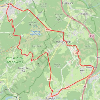
Arjan_smit_3_course
- Distance: 39.9 Km
- Elevation gain: 910 m
- Maximum elevation: 568 m
- Elevation loss: 913 m
- Minimum elevation: 250 m
- Moving time: 3 h 59 m
- Moving speed: 10.0 Km/h
- Maximum speed: 13.0 Km/h
- Total time: 3 h 59 m
- Global speed: 10.0 Km/h
Interactive trail map
Trail profile
- Distance: 39.9 Km
- Elevation gain: 910 m
- Maximum elevation: 568 m
- Elevation loss: 913 m
- Minimum elevation: 250 m
- Moving time: 3 h 59 m
- Moving speed: 10.0 Km/h
- Maximum speed: 13.0 Km/h
- Total time: 3 h 59 m
- Global speed: 10.0 Km/h
About this trail
Name: Arjan_smit_3_course trail, distance, elevation, map, profile, GPS track
Start: Place Royale, Spa, Verviers, Liège, Wallonia, 4900, Belgium (50.49244 5.86471)
End: Place Royale, Spa, Verviers, Liège, Wallonia, 4900, Belgium (50.49241 5.86389)
Coordinates: 50.39636 5.85965 50.49245 6.00110
Other hiking, mountain biking, running and outdoor activity trails
Click on a trail to view its statistics, map and profile.
Arjan_smit_1_course
Belgium > Liège > Verviers > Spa
Distance: 39.8 Km • Elevation gain: 815 m • Maximum elevation: 561 m
GR005_Parcours-principal_2021-05-06
Netherlands > Limburg > Maastricht
GR005_Parcours-principal_2021-05-06
Distance: 331.2 Km • Elevation gain: 8,983 m • Maximum elevation: 572 m
Riethoven naar Oostenrijk
Netherlands > North Brabant > Riethoven > Eind
Distance: 922.1 Km • Elevation gain: 13,629 m • Maximum elevation: 1,897 m
Eurovelo 15 - Strasbourg Rotterdam
France > Grand Est > Bas-Rhin > Strasbourg
Distance: 891.7 Km • Elevation gain: 2,104 m • Maximum elevation: 146 m
LT25_FINAL
Belgium > Luxembourg > Bastogne > Mont
Distance: 276.0 Km • Elevation gain: 10,191 m • Maximum elevation: 626 m