Pound Bend Loop
Warrandyte State Park. Yarra River. #Hiking #Loop #Warrandyte
- Distance: 6.5 Km
- Elevation gain: 104 m
- Maximum elevation: 84 m
- Elevation loss: 104 m
- Minimum elevation: 27 m
- Moving time: 1 h 7 m
- Moving speed: 5.7 Km/h
- Maximum speed: 8.2 Km/h
- Total time: 1 h 8 m
- Global speed: 5.6 Km/h
Interactive trail map
Trail profile
- Distance: 6.5 Km
- Elevation gain: 104 m
- Maximum elevation: 84 m
- Elevation loss: 104 m
- Minimum elevation: 27 m
- Moving time: 1 h 7 m
- Moving speed: 5.7 Km/h
- Maximum speed: 8.2 Km/h
- Total time: 1 h 8 m
- Global speed: 5.6 Km/h
About this trail
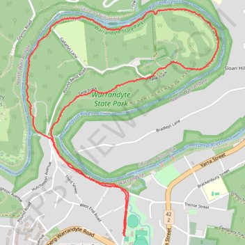
Name: Pound Bend Loop trail, distance, elevation, map, profile, GPS track
Coordinates: -37.74560 145.19847 -37.73016 145.21498
Topography: Melbourne topographic map, elevation, terrain
Other hiking, mountain biking, running and outdoor activity trails
Click on a trail to view its statistics, map and profile.
Tallarook - Eildon - Hurstbridge
Australia > Victoria > Tallarook
#Bike
Distance: 278.8 Km • Elevation gain: 4,897 m • Maximum elevation: 868 m