Castle Eden Dene walk
County Durham Walking
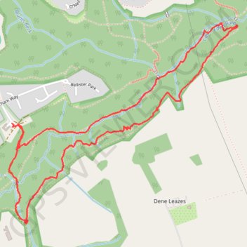
- Distance: 4.3 Km
- Elevation gain: 125 m
- Maximum elevation: 95 m
- Elevation loss: 126 m
- Minimum elevation: 43 m
- Moving time: 1 h 22 m
- Moving speed: 3.1 Km/h
- Maximum speed: 8.5 Km/h
- Total time: 1 h 31 m
- Global speed: 2.8 Km/h
Interactive trail map
Trail profile
- Distance: 4.3 Km
- Elevation gain: 125 m
- Maximum elevation: 95 m
- Elevation loss: 126 m
- Minimum elevation: 43 m
- Moving time: 1 h 22 m
- Moving speed: 3.1 Km/h
- Maximum speed: 8.5 Km/h
- Total time: 1 h 31 m
- Global speed: 2.8 Km/h
About this trail
Name: Castle Eden Dene walk trail, distance, elevation, map, profile, GPS track
Coordinates: 54.74288 -1.33736 54.75204 -1.31935
Other hiking, mountain biking, running and outdoor activity trails
Click on a trail to view its statistics, map and profile.
Castle Eden Dene walk
United Kingdom > England > County Durham > Peterlee
County Durham Walking
Distance: 4.0 Km • Elevation gain: 112 m • Maximum elevation: 115 m