Thank you for supporting this site ❤️
Make a donation
Make a donation
Gear up for your next adventure:
As an Amazon Associate, this site earns from qualifying purchases at no extra cost to you.
Wisley Airfield & Lane
Wonder how much longer the airfield will be accessible
- Distance: 5.1 Km
- Elevation gain: 32 m
- Maximum elevation: 43 m
- Elevation loss: 31 m
- Minimum elevation: 23 m
- Moving time: 28 m 10 s
- Moving speed: 10.9 Km/h
- Maximum speed: 15.0 Km/h
- Total time: 28 m 10 s
- Global speed: 10.9 Km/h
Interactive trail map
Thank you for supporting this site ❤️
Make a donation
Make a donation
Gear up for your next adventure:
As an Amazon Associate, this site earns from qualifying purchases at no extra cost to you.
Trail profile
- Distance: 5.1 Km
- Elevation gain: 32 m
- Maximum elevation: 43 m
- Elevation loss: 31 m
- Minimum elevation: 23 m
- Moving time: 28 m 10 s
- Moving speed: 10.9 Km/h
- Maximum speed: 15.0 Km/h
- Total time: 28 m 10 s
- Global speed: 10.9 Km/h
Thank you for supporting this site ❤️
Make a donation
Make a donation
Gear up for your next adventure:
As an Amazon Associate, this site earns from qualifying purchases at no extra cost to you.
About this trail
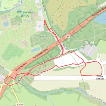
Name: Wisley Airfield & Lane trail, distance, elevation, map, profile, GPS track
Coordinates: 51.30549 -0.47904 51.31415 -0.45820
Thank you for supporting this site ❤️
Make a donation
Make a donation
Gear up for your next adventure:
As an Amazon Associate, this site earns from qualifying purchases at no extra cost to you.