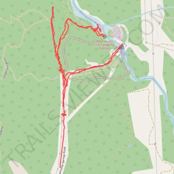
Mamquam Falls
- Distance: 3.8 Km
- Elevation gain: 111 m
- Maximum elevation: 117 m
- Elevation loss: 122 m
- Minimum elevation: 62 m
- Moving time: 47 m 15 s
- Moving speed: 4.8 Km/h
- Maximum speed: 21.3 Km/h
- Total time: 57 m 35 s
- Global speed: 3.9 Km/h
Interactive trail map
Trail profile
- Distance: 3.8 Km
- Elevation gain: 111 m
- Maximum elevation: 117 m
- Elevation loss: 122 m
- Minimum elevation: 62 m
- Moving time: 47 m 15 s
- Moving speed: 4.8 Km/h
- Maximum speed: 21.3 Km/h
- Total time: 57 m 35 s
- Global speed: 3.9 Km/h
About this trail
Name: Mamquam Falls trail, distance, elevation, map, profile, GPS track
Coordinates: 49.71510 -123.09654 49.72254 -123.09142
Other hiking, mountain biking, running and outdoor activity trails
Click on a trail to view its statistics, map and profile.