Make a donation
Gear up for your next adventure:
As an Amazon Associate, this site earns from qualifying purchases at no extra cost to you.
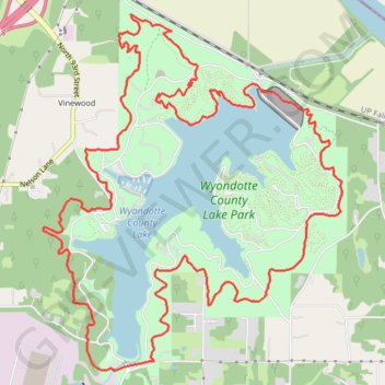
Wyandotte County Lake Bridle Loop Trail
The Wyandotte County Lake Bridle Loop Trail offers a refreshing outdoor experience with picturesque views of the lake and surrounding woodlands. As you hike, you'll encounter diverse wildlife, particularly a variety of birds, and the trail's peaceful ambiance is perfect for both solo explorers and families. The well-maintained path allows for a leisurely stroll or a brisk run, making it an inviting destination for outdoor enthusiasts year-round. #Hiking #Loop #Lake #Forest #Nature
- Distance: 17.1 Km
- Elevation gain: 332 m
- Maximum elevation: 295 m
- Elevation loss: 332 m
- Minimum elevation: 235 m
- Moving time: 3 h 34 m
- Moving speed: 4.8 Km/h
- Maximum speed: 9.0 Km/h
- Total time: 3 h 50 m
- Global speed: 4.4 Km/h
Interactive trail map
Make a donation
Gear up for your next adventure:
As an Amazon Associate, this site earns from qualifying purchases at no extra cost to you.
Trail profile
- Distance: 17.1 Km
- Elevation gain: 332 m
- Maximum elevation: 295 m
- Elevation loss: 332 m
- Minimum elevation: 235 m
- Moving time: 3 h 34 m
- Moving speed: 4.8 Km/h
- Maximum speed: 9.0 Km/h
- Total time: 3 h 50 m
- Global speed: 4.4 Km/h
Make a donation
Gear up for your next adventure:
As an Amazon Associate, this site earns from qualifying purchases at no extra cost to you.
About this trail
Name: Wyandotte County Lake Bridle Loop Trail trail, distance, elevation, map, profile, GPS track
Coordinates: 39.14958 -94.79711 39.17891 -94.76531
Make a donation
Gear up for your next adventure:
As an Amazon Associate, this site earns from qualifying purchases at no extra cost to you.