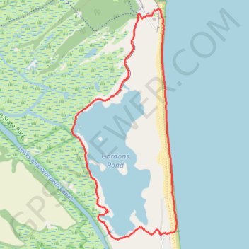
Gordons Pond Loop via Overlook and Beach in Cape Henlopen State Park
The Gordons Pond Loop offers a serene hiking experience through diverse landscapes, including picturesque salt marshes, tranquil wooded areas and the beach along the Atlantic Ocean. As you traverse the well-maintained trail, you can enjoy breathtaking views of the pond and the sea, watch for various bird species, and appreciate the historical significance of the nearby World War II fire control towers. The combination of nature and history makes this route not only visually appealing but also enriching, inviting both casual walkers and avid nature enthusiasts to immerse themselves in its beauty. #Hiking #Loop #Lake #Sea #Ocean #Atlantic #Forest #Nature
- Distance: 7.8 Km
- Elevation gain: 24 m
- Maximum elevation: 9 m
- Elevation loss: 24 m
- Minimum elevation: -3 m
- Moving time: 2 h 6 m
- Moving speed: 3.7 Km/h
- Maximum speed: 5.5 Km/h
- Total time: 2 h 21 m
- Global speed: 3.3 Km/h
Interactive trail map
Trail profile
- Distance: 7.8 Km
- Elevation gain: 24 m
- Maximum elevation: 9 m
- Elevation loss: 24 m
- Minimum elevation: -3 m
- Moving time: 2 h 6 m
- Moving speed: 3.7 Km/h
- Maximum speed: 5.5 Km/h
- Total time: 2 h 21 m
- Global speed: 3.3 Km/h
About this trail
Name: Gordons Pond Loop via Overlook and Beach in Cape Henlopen State Park trail, distance, elevation, map, profile, GPS track
Start: Ocean Drive, North Shores, Sussex County, Delaware, 19971, United States (38.74209 -75.08194)
End: Ocean Drive, North Shores, Sussex County, Delaware, 19971, United States (38.74219 -75.08185)
Coordinates: 38.74158 -75.09428 38.76647 -75.07977
Other hiking, mountain biking, running and outdoor activity trails
Click on a trail to view its statistics, map and profile.
Gordons Pond Trail in Cape Henlopen State Park
United States > Delaware > Sussex County
Gordons Pond Trail offers a delightful experience for hikers and cyclists alike, winding through stunning salt marshes and providing breathtaking views of the surrounding wildlife. Along the route, you can expect to encounter diverse bird species, particularly during migration seasons, making it a haven for…
Distance: 10.3 Km • Elevation gain: 37 m • Maximum elevation: 8 m