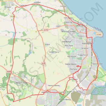
Hartlepool Loop
- Distance: 56.4 Km
- Elevation gain: 335 m
- Maximum elevation: 137 m
- Elevation loss: 335 m
- Minimum elevation: -1 m
- Moving time: 2 h 48 m
- Moving speed: 20.1 Km/h
- Maximum speed: 43.0 Km/h
- Total time: 2 h 59 m
- Global speed: 18.8 Km/h
Interactive trail map
Trail profile
- Distance: 56.4 Km
- Elevation gain: 335 m
- Maximum elevation: 137 m
- Elevation loss: 335 m
- Minimum elevation: -1 m
- Moving time: 2 h 48 m
- Moving speed: 20.1 Km/h
- Maximum speed: 43.0 Km/h
- Total time: 2 h 59 m
- Global speed: 18.8 Km/h
About this trail
Name: Hartlepool Loop trail, distance, elevation, map, profile, GPS track
Coordinates: 54.61236 -1.38205 54.73469 -1.18400
Other hiking, mountain biking, running and outdoor activity trails
Click on a trail to view its statistics, map and profile.
Hartlepool Bicycle
United Kingdom > England > Hartlepool
Distance: 23.5 Km • Elevation gain: 66 m • Maximum elevation: 23 m