Shakota Trail
Most of the trail from south to north, went off track a bit, nice trail.
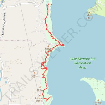
- Distance: 6.1 Km
- Elevation gain: 173 m
- Maximum elevation: 268 m
- Elevation loss: 211 m
- Minimum elevation: 229 m
- Moving time: 1 h 45 m
- Moving speed: 3.4 Km/h
- Maximum speed: 8.6 Km/h
- Total time: 2 h 27 m
- Global speed: 2.5 Km/h
Interactive trail map
Trail profile
- Distance: 6.1 Km
- Elevation gain: 173 m
- Maximum elevation: 268 m
- Elevation loss: 211 m
- Minimum elevation: 229 m
- Moving time: 1 h 45 m
- Moving speed: 3.4 Km/h
- Maximum speed: 8.6 Km/h
- Total time: 2 h 27 m
- Global speed: 2.5 Km/h
About this trail
Name: Shakota Trail trail, distance, elevation, map, profile, GPS track
Start: Shakota Trail, Calpella, Mendocino County, California, 95418, United States (39.20557 -123.18449)
End: Shakota Trail, Calpella, Mendocino County, California, 95418, United States (39.23180 -123.18266)
Coordinates: 39.20557 -123.18637 39.23217 -123.17810