Make a donation
Gear up for your next adventure:
As an Amazon Associate, this site earns from qualifying purchases at no extra cost to you.
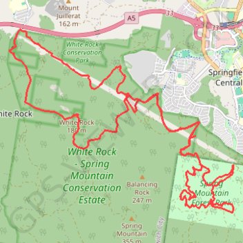
White Rock - Spring Mountain Conservation Estate
#MTB #Loop #WhiteRock #SpringMountain
- Distance: 30.8 Km
- Elevation gain: 882 m
- Maximum elevation: 211 m
- Elevation loss: 883 m
- Minimum elevation: 66 m
Interactive trail map
Make a donation
Gear up for your next adventure:
As an Amazon Associate, this site earns from qualifying purchases at no extra cost to you.
Trail profile
- Distance: 30.8 Km
- Elevation gain: 882 m
- Maximum elevation: 211 m
- Elevation loss: 883 m
- Minimum elevation: 66 m
Make a donation
Gear up for your next adventure:
As an Amazon Associate, this site earns from qualifying purchases at no extra cost to you.
About this trail
Name: White Rock - Spring Mountain Conservation Estate trail, distance, elevation, map, profile, GPS track
Coordinates: -27.71682 152.84754 -27.67548 152.90502
Topography: Queensland topographic map, elevation, terrain
Make a donation
Gear up for your next adventure:
As an Amazon Associate, this site earns from qualifying purchases at no extra cost to you.
Other hiking, mountain biking, running and outdoor activity trails
Click on a trail to view its statistics, map and profile.
White Rock - Spring Mountain Conservation Estate
#MTB #WhiteRock #SpringMountain
Distance: 38.8 Km • Elevation gain: 901 m • Maximum elevation: 326 m
Kessel Run
Australia > Queensland > Ipswich City
Distance: 1.0 Km • Elevation gain: 36 m • Maximum elevation: 119 m