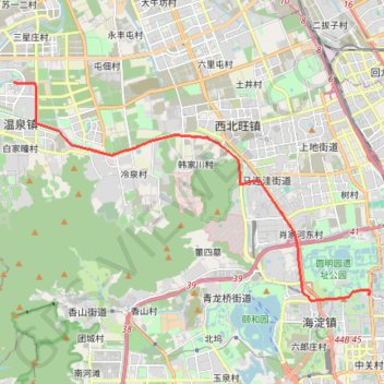
轨迹 20240227-080007
- Distance: 17.4 Km
- Elevation gain: 43 m
- Maximum elevation: 60 m
- Elevation loss: 43 m
- Minimum elevation: 46 m
- Moving time: 30 m 17 s
- Moving speed: 34.5 Km/h
- Maximum speed: 74.6 Km/h
- Total time: 34 m 56 s
- Global speed: 29.9 Km/h
Interactive trail map
Trail profile
- Distance: 17.4 Km
- Elevation gain: 43 m
- Maximum elevation: 60 m
- Elevation loss: 43 m
- Minimum elevation: 46 m
- Moving time: 30 m 17 s
- Moving speed: 34.5 Km/h
- Maximum speed: 74.6 Km/h
- Total time: 34 m 56 s
- Global speed: 29.9 Km/h
About this trail
Name: 轨迹 20240227-080007 trail, distance, elevation, map, profile, GPS track
Start: 中国科学院计算技术研究所/龙芯产业园, 景天路, Sujiatuo, Haidian District, Beijing, China (40.05979 116.17211)
Coordinates: 39.99530 116.17211 40.05980 116.30889