Thank you for supporting this site ❤️
Make a donation
Make a donation
Gear up for your next adventure:
As an Amazon Associate, this site earns from qualifying purchases at no extra cost to you.
Exploring Farnhill
Run
- Distance: 5.0 Km
- Elevation gain: 129 m
- Maximum elevation: 205 m
- Elevation loss: 131 m
- Minimum elevation: 91 m
- Moving time: 1 h 1 m
- Moving speed: 4.8 Km/h
- Maximum speed: 9.6 Km/h
- Total time: 1 h 5 m
- Global speed: 4.6 Km/h
Interactive trail map
Thank you for supporting this site ❤️
Make a donation
Make a donation
Gear up for your next adventure:
As an Amazon Associate, this site earns from qualifying purchases at no extra cost to you.
Trail profile
- Distance: 5.0 Km
- Elevation gain: 129 m
- Maximum elevation: 205 m
- Elevation loss: 131 m
- Minimum elevation: 91 m
- Moving time: 1 h 1 m
- Moving speed: 4.8 Km/h
- Maximum speed: 9.6 Km/h
- Total time: 1 h 5 m
- Global speed: 4.6 Km/h
Thank you for supporting this site ❤️
Make a donation
Make a donation
Gear up for your next adventure:
As an Amazon Associate, this site earns from qualifying purchases at no extra cost to you.
About this trail
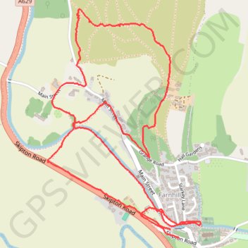
Name: Exploring Farnhill trail, distance, elevation, map, profile, GPS track
Coordinates: 53.90900 -1.99574 53.91896 -1.98446
Thank you for supporting this site ❤️
Make a donation
Make a donation
Gear up for your next adventure:
🐍Australian Snake Bite Kits - Specific pressure immobilization bandages for Australian venomous snakes
As an Amazon Associate, this site earns from qualifying purchases at no extra cost to you.