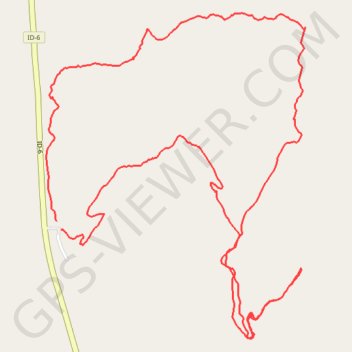
White Pine loop hike
- Distance: 7.9 Km
- Elevation gain: 351 m
- Maximum elevation: 975 m
- Elevation loss: 350 m
- Minimum elevation: 849 m
- Moving time: 2 h 38 m
- Moving speed: 3.0 Km/h
- Maximum speed: 6.1 Km/h
- Total time: 5 h 23 m
- Global speed: 1.5 Km/h
Interactive trail map
Trail profile
- Distance: 7.9 Km
- Elevation gain: 351 m
- Maximum elevation: 975 m
- Elevation loss: 350 m
- Minimum elevation: 849 m
- Moving time: 2 h 38 m
- Moving speed: 3.0 Km/h
- Maximum speed: 6.1 Km/h
- Total time: 5 h 23 m
- Global speed: 1.5 Km/h
About this trail
Name: White Pine loop hike trail, distance, elevation, map, profile, GPS track
Start: Giant White Pine Campground, ID-6, Latah County, Idaho, United States (47.01046 -116.67749)
End: ID-6, Latah County, Idaho, United States (47.01083 -116.67782)
Coordinates: 47.00557 -116.67850 47.02015 -116.66144