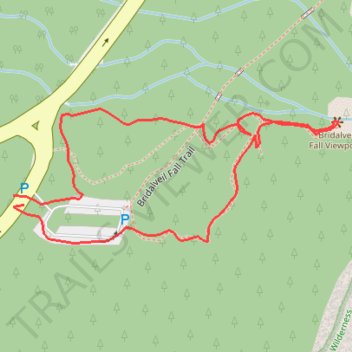
Bridalveil Fall Viewpoint
- Distance: 1.1 Km
- Elevation gain: 25 m
- Maximum elevation: 1,222 m
- Elevation loss: 25 m
- Minimum elevation: 1,198 m
- Moving time: 20 m 7 s
- Moving speed: 3.3 Km/h
- Maximum speed: 7.2 Km/h
- Total time: 21 m
- Global speed: 3.1 Km/h
Interactive trail map
Trail profile
- Distance: 1.1 Km
- Elevation gain: 25 m
- Maximum elevation: 1,222 m
- Elevation loss: 25 m
- Minimum elevation: 1,198 m
- Moving time: 20 m 7 s
- Moving speed: 3.3 Km/h
- Maximum speed: 7.2 Km/h
- Total time: 21 m
- Global speed: 3.1 Km/h
About this trail
Name: Bridalveil Fall Viewpoint trail, distance, elevation, map, profile, GPS track
Start: 7932, Wawona Road, Mariposa County, California, 95389, United States (37.71678 -119.65216)
End: 7932, Wawona Road, Mariposa County, California, 95389, United States (37.71687 -119.65228)
Coordinates: 37.71641 -119.65229 37.71772 -119.64826