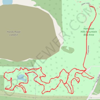
Hampton Hills MTB D Loop
Akron Mountain Biking
- Distance: 10.4 Km
- Elevation gain: 113 m
- Maximum elevation: 287 m
- Elevation loss: 112 m
- Minimum elevation: 265 m
- Moving time: 1 h 13 m
- Moving speed: 8.5 Km/h
- Maximum speed: 15.7 Km/h
- Total time: 1 h 27 m
- Global speed: 7.1 Km/h
Interactive trail map
Trail profile
- Distance: 10.4 Km
- Elevation gain: 113 m
- Maximum elevation: 287 m
- Elevation loss: 112 m
- Minimum elevation: 265 m
- Moving time: 1 h 13 m
- Moving speed: 8.5 Km/h
- Maximum speed: 15.7 Km/h
- Total time: 1 h 27 m
- Global speed: 7.1 Km/h
About this trail
Name: Hampton Hills MTB D Loop trail, distance, elevation, map, profile, GPS track
Coordinates: 41.14864 -81.56118 41.15701 -81.54945
Other hiking, mountain biking, running and outdoor activity trails
Click on a trail to view its statistics, map and profile.
Hampton Hills MTB A, B, and C loops, multiband x2
United States > Ohio > Summit County > Akron
Akron Mountain Biking
Distance: 5.8 Km • Elevation gain: 45 m • Maximum elevation: 287 m
Hampton Hills MTB lower sections
United States > Ohio > Summit County > Akron
Distance: 9.0 Km • Elevation gain: 119 m • Maximum elevation: 287 m