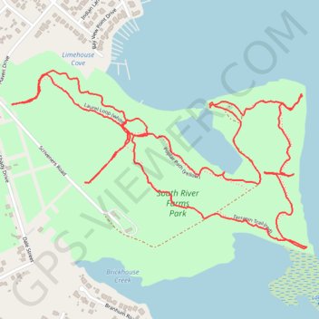
South River Farm Park
- Distance: 4.9 Km
- Elevation gain: 49 m
- Maximum elevation: 14 m
- Elevation loss: 49 m
- Minimum elevation: 1 m
- Moving time: 1 h 26 m
- Moving speed: 3.4 Km/h
- Maximum speed: 20.7 Km/h
- Total time: 1 h 41 m
- Global speed: 2.9 Km/h
Interactive trail map
Trail profile
- Distance: 4.9 Km
- Elevation gain: 49 m
- Maximum elevation: 14 m
- Elevation loss: 49 m
- Minimum elevation: 1 m
- Moving time: 1 h 26 m
- Moving speed: 3.4 Km/h
- Maximum speed: 20.7 Km/h
- Total time: 1 h 41 m
- Global speed: 2.9 Km/h
About this trail
Name: South River Farm Park trail, distance, elevation, map, profile, GPS track
Coordinates: 38.91508 -76.51999 38.92035 -76.50879