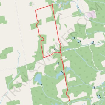
Bruce Trail Duffering Hi-Lands Prince of Wales Honeywood section
- Distance: 9.6 Km
- Elevation gain: 232 m
- Maximum elevation: 519 m
- Elevation loss: 231 m
- Minimum elevation: 388 m
- Moving time: 1 h 50 m
- Moving speed: 5.2 Km/h
- Maximum speed: 43.6 Km/h
- Total time: 2 h 30 m
- Global speed: 3.8 Km/h
Interactive trail map
Trail profile
- Distance: 9.6 Km
- Elevation gain: 232 m
- Maximum elevation: 519 m
- Elevation loss: 231 m
- Minimum elevation: 388 m
- Moving time: 1 h 50 m
- Moving speed: 5.2 Km/h
- Maximum speed: 43.6 Km/h
- Total time: 2 h 30 m
- Global speed: 3.8 Km/h
About this trail
Name: Bruce Trail Duffering Hi-Lands Prince of Wales Honeywood section trail, distance, elevation, map, profile, GPS track
Start: Bruce Trail, Mulmur, Dufferin County, Central Ontario, Ontario, L0N 1H0, Canada (44.21635 -80.16809)
End: Bruce Trail, Mulmur, Dufferin County, Central Ontario, Ontario, L9V 0C5, Canada (44.21629 -80.16817)
Coordinates: 44.18330 -80.17618 44.21639 -80.16014
Other hiking, mountain biking, running and outdoor activity trails
Click on a trail to view its statistics, map and profile.
Owen Sound - Orangeville
Canada > Ontario > Grey County > Owen Sound
Distance: 107.6 Km • Elevation gain: 593 m • Maximum elevation: 517 m
Trails on the property of Unicamp of Ontario
Canada > Ontario > Dufferin County > Mulmur
Distance: 3.0 Km • Elevation gain: 36 m • Maximum elevation: 457 m
Ontario country roads
Distance: 150.4 Km • Elevation gain: 1,137 m • Maximum elevation: 497 m