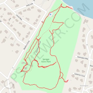
Spriggs Farm Park Loop
- Distance: 3.4 Km
- Elevation gain: 30 m
- Maximum elevation: 20 m
- Elevation loss: 30 m
- Minimum elevation: 2 m
- Moving time: 56 m 8 s
- Moving speed: 3.6 Km/h
- Maximum speed: 8.6 Km/h
- Total time: 1 h 10 m
- Global speed: 2.9 Km/h
Interactive trail map
Trail profile
- Distance: 3.4 Km
- Elevation gain: 30 m
- Maximum elevation: 20 m
- Elevation loss: 30 m
- Minimum elevation: 2 m
- Moving time: 56 m 8 s
- Moving speed: 3.6 Km/h
- Maximum speed: 8.6 Km/h
- Total time: 1 h 10 m
- Global speed: 2.9 Km/h
About this trail
Name: Spriggs Farm Park Loop trail, distance, elevation, map, profile, GPS track
Coordinates: 39.05542 -76.47639 39.06074 -76.47227