Make a donation
Gear up for your next adventure:
As an Amazon Associate, this site earns from qualifying purchases at no extra cost to you.
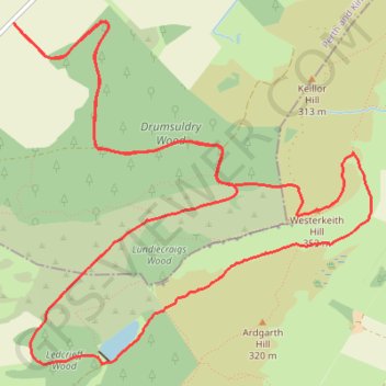
Mountain Bike Ride Around Westerkeith Hill
Loop MTB via Drumsuldry Wood, Westerkeith Hill, Ledcrieff Loch, Ledcrieff Wood and Lundiecraigs Wood. #MTB #Loop #Nature #Forest #Countryside
- Distance: 9.9 Km
- Elevation gain: 279 m
- Maximum elevation: 343 m
- Elevation loss: 279 m
- Minimum elevation: 156 m
- Moving time: 1 h 4 m
- Moving speed: 9.3 Km/h
- Maximum speed: 24.6 Km/h
- Total time: 1 h 7 m
- Global speed: 8.8 Km/h
Interactive trail map
Make a donation
Gear up for your next adventure:
As an Amazon Associate, this site earns from qualifying purchases at no extra cost to you.
Trail profile
- Distance: 9.9 Km
- Elevation gain: 279 m
- Maximum elevation: 343 m
- Elevation loss: 279 m
- Minimum elevation: 156 m
- Moving time: 1 h 4 m
- Moving speed: 9.3 Km/h
- Maximum speed: 24.6 Km/h
- Total time: 1 h 7 m
- Global speed: 8.8 Km/h
Make a donation
Gear up for your next adventure:
As an Amazon Associate, this site earns from qualifying purchases at no extra cost to you.
About this trail
Name: Mountain Bike Ride Around Westerkeith Hill trail, distance, elevation, map, profile, GPS track
Coordinates: 56.51929 -3.19729 56.53611 -3.16554
Make a donation
Gear up for your next adventure:
As an Amazon Associate, this site earns from qualifying purchases at no extra cost to you.
Other hiking, mountain biking, running and outdoor activity trails
Click on a trail to view its statistics, map and profile.
Around Keillor Hill
United Kingdom > Scotland > Perth and Kinross > Piperdam > South Dronley
Distance: 9.1 Km • Elevation gain: 234 m • Maximum elevation: 330 m