Thank you for supporting this site ❤️
Make a donation
Make a donation
Gear up for your next adventure:
🐍Australian Snake Bite Kits - Specific pressure immobilization bandages for Australian venomous snakes
As an Amazon Associate, this site earns from qualifying purchases at no extra cost to you.
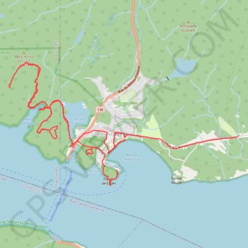
Tadoussac
Saint Lawrence River. #Hiking #Loop #SaintLawrence
- Distance: 17.6 Km
- Elevation gain: 769 m
- Maximum elevation: 294 m
- Elevation loss: 709 m
- Minimum elevation: 0 m
Interactive trail map
Thank you for supporting this site ❤️
Make a donation
Make a donation
Gear up for your next adventure:
As an Amazon Associate, this site earns from qualifying purchases at no extra cost to you.
Trail profile
- Distance: 17.6 Km
- Elevation gain: 769 m
- Maximum elevation: 294 m
- Elevation loss: 709 m
- Minimum elevation: 0 m
Thank you for supporting this site ❤️
Make a donation
Make a donation
Gear up for your next adventure:
As an Amazon Associate, this site earns from qualifying purchases at no extra cost to you.
About this trail
Name: Tadoussac trail, distance, elevation, map, profile, GPS track
Coordinates: 48.13503 -69.74070 48.15479 -69.68544
Thank you for supporting this site ❤️
Make a donation
Make a donation
Gear up for your next adventure:
As an Amazon Associate, this site earns from qualifying purchases at no extra cost to you.